Der Eintrag
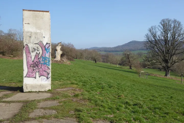
Ein Segment, das jahrelang als landwirtschaftliches Gerät in Brandenburg diente, bevor es auf das Fundament einer amerikanischen Armeebaracke von 1944 unterhalb der Malvern Hills gesetzt wurde.
Die ausführliche Geschichte, die Herkunft und die Quellenangaben dieses Eintrags liegen bislang nur auf Englisch vor.
An original segment from the north of central Berlin stands in open parkland at the edge of the Malvern Hills, on the foundation of a hut built for the United States Army in 1944. The Berlin Wall Foundation catalogues it as MAU-782, recorded in December 2025, and describes it as one of eight locations in Great Britain holding a piece of the Wall.
What it did in between is the part worth knowing. After the border came down the segment was put to agricultural use near Meyenburg in Brandenburg.
That is not an indignity, and it is not a coincidence either. The Grenzmauer 75 element was derived from a precast component farmers used to build open silos: an L-shaped section that stands on any firm ground without a foundation and holds back whatever is piled against it. The GDR adopted it because it was cheap, quick and presented a clean face to the west. When the border stopped being a border, a Brandenburg farm simply used the thing for what its shape was always for, and it went back to holding silage until somebody wanted it as history.
Of the roughly 45,000 elements, this catalogue can follow only a few hundred. This one went from a state border to a field to an English deer park, and the middle stage is the one almost no record preserves.
Wie kam es hierher?
From the north of central Berlin; used for agricultural purposes near Meyenburg in Brandenburg after the fall of the Wall, and later placed in the deer park on the foundation of a 1944 United States Army hut.
Quellen
MAU-782 Berliner Mauerelement im Eastnor Deer Park — MAUERSPUREN, Stiftung Berliner Mauer ↗
An original segment from the north of central Berlin standing in open parkland at the edge of the Malvern Hills on the foundation of a former 1944 US Army hut, used for agricultural purposes near Meyenburg after the fall of the Wall, described as one of eight locations in Great Britain, catalogued as MAU-782 and recorded in December 2025.
Institutionelle QuelleQuelle abgerufen am 2026-09-17
Niederkirchnerstraße — Landesdenkmalamt Berlin, Wall monuments ↗
The Grenzmauer 75 was made of L-shaped precast concrete sections of the kind farmers used to build open silos, standing without a foundation on any firm soil.
Institutionelle QuelleQuelle abgerufen am 2026-09-17
Wissen Sie mehr über dieses Stück – wann es ankam, wer es gab, was auf der Tafel steht? Zu diesem Eintrag beitragen (Englisch)