The record
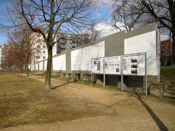
Wall through an eighteenth-century military cemetery, where graves were cleared for the death strip and the gravestones were used to pave a street.
The Invalidenfriedhof was founded in 1748 on the orders of Friedrich II for the soldiers' hospital next to it, and its western boundary runs along the bank of the Spandau ship canal. When the Allies drew the sector boundary after the war they ran it down the middle of that canal, and from 13 August 1961 the cemetery was progressively eaten by the border installations. Whole sections of it — E, F and G — were cleared for the strip, most thoroughly in 1973 and 1975, and the gravestones standing in the restricted area in front of the hinterland wall went with them. As at the cemeteries on Bernauer Straße, graves by the border were razed and the stones used to pave a street.
It was not cleared completely, and the reason is a small study in whose memory counts. The cemetery holds the graves of Gerhard von Scharnhorst, whose monument was designed by Schinkel, and of Friedrich Friesen of the Wars of Liberation — figures the GDR revered as much as anyone else did. That is what saved the rest of it.
The cemetery's own western wall, brick, built along the canal bank in 1902, was reinforced with a fence and pressed into service as the border wall; the same absorption of an older wall happened at the Nordbahnhof and along the Ulbricht curve. About 180 metres of hinterland wall sections survive, with a somewhat longer run of the patrol track that had cut through the cemetery since 1975. They were given protected status in 1990, and in 2003 the Landesdenkmalamt restored the concrete and repainted it in the pattern used on the eastern face — long white rectangles framed in grey.
Along Liesenstraße itself fifteen metres of the border wall proper, a Grenzmauer 75 run badly chewed by souvenir hunters, stands on the cemetery ground, with two further hinterland segments near the entrance. Because the Invalidenfriedhof is also an important historic garden, preserving the border strip and restoring the cemetery had to be reconciled; the former no man's land is now part of the riverside promenade from the Sandkrugbrücke to the Nordhafen.
How did it get here?
In place. Protected since 1990; the concrete was restored and repainted by the Landesdenkmalamt in 2003.
Sources & verification
Berlin Wall: where it still stands — Berlin.de ↗
Surviving wall along Liesenstraße and through the Invalidenfriedhof.
Source accessed 2026-09-17
Der Invalidenfriedhof — Landesdenkmalamt Berlin, Wall monuments ↗
The cemetery's founding in 1748 for the Invalidenhaus, the sector boundary down the middle of the Spandau ship canal, the clearing of sections E, F and G in 1973 and 1975 and the destruction of gravestones in the restricted area, the 1902 brick boundary wall reinforced as a border wall, the graves of Scharnhorst and Friesen that saved the cemetery from complete clearance, the roughly 180 metres of hinterland wall and the longer stretch of patrol track protected in 1990, the 2003 restoration and repainting in the eastern colour scheme, and the riverside promenade along the former no man's land.
Source accessed 2026-09-17
Rund um den Nordbahnhof — Landesdenkmalamt Berlin, Wall monuments ↗
Fifteen metres of the Grenzmauer 75 border wall on the cemetery grounds along Liesenstraße, mutilated by souvenir-seekers, two hinterland wall segments near the cemetery entrance, and the razing of graves by the border with the gravestones used to pave a street.
Source accessed 2026-09-17
Last verified: Not yet verified
Our sourcing standardsKnow more about this piece — when it arrived, who gave it, what the plaque says? Contribute to this record