The record
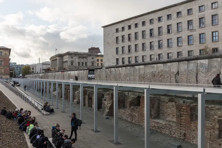
About 200 m of border wall left rough and chewed by the Mauerspechte — and the clearest description anywhere of what the object in this catalogue actually is.
Roughly 200 metres of original border wall runs along the southern side of Niederkirchnerstraße, past the Topography of Terror, on the line the installations took from Stresemannstraße towards Checkpoint Charlie. It has been left rough rather than restored, and it is the best surviving evidence of what the Mauerspechte — the wall-peckers — did to the structure: the concrete is hollowed out in patches, the reinforcing bars exposed, the top edge broken away. Most preserved sections elsewhere have been tidied. This one records the months in 1990 when the Wall was being taken apart by hand, with hammers, by anyone who wanted a piece — which is where a large share of the fragments in this catalogue came from.
It is also the plainest example of the object itself. This is the Grenzmauer 75, the fourth generation of the Wall, which began replacing its predecessors in the mid-1970s after a large development and testing programme. Each element is an L-shaped section of precast concrete of a kind farmers used to build open silos, 3.60 metres high and 1.20 metres wide, finished with a smooth asbestos-concrete pipe 40 centimetres across along the top. Its advantages over what came before were the base, which could stand on any firm soil without a foundation; a construction robust enough to resist almost any attempt to drive a vehicle through it; and the clean, uniform face it turned to the west.
That last advantage is worth holding on to while reading the rest of this catalogue. The thing that was exported, auctioned, painted and given away all over the world is a mass-produced agricultural component, chosen partly because it looked tidy from the other side.
How did it get here?
Original position, listed as an architectural monument. The damage is part of what is preserved.
Sources & verification
Berlin Wall: where it still stands — Berlin.de ↗
The surviving stretch along Niederkirchnerstraße beside the Topography of Terror.
Source accessed 2026-09-17
Niederkirchnerstraße — Landesdenkmalamt Berlin, Wall monuments ↗
The roughly 200-metre run of Grenzmauer 75 border wall on the southern side of Niederkirchnerstraße, damaged by souvenir-seekers and standing at its original location, and the description of the Grenzmauer 75 as the fourth generation introduced in the mid-1970s: L-shaped precast sections of the type used for open silos, 3.60 metres high and 1.20 metres wide, topped by a 40-centimetre asbestos-concrete pipe, needing no foundation, resistant to vehicles, and presenting clean uniform lines to the west.
Source accessed 2026-09-17
Last verified: Not yet verified
Our sourcing standardsKnow more about this piece — when it arrived, who gave it, what the plaque says? Contribute to this record